


Voting District 16, Pontotoc County, Oklahoma
About
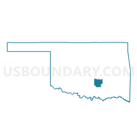
Outline

Summary
| Unique Area Identifier | 655049 |
| Name | Voting District 16 |
| County | Pontotoc County |
| State | Oklahoma |
| Area (square miles) | 21.77 |
| Land Area (square miles) | 21.48 |
| Water Area (square miles) | 0.29 |
| % of Land Area | 98.68 |
| % of Water Area | 1.32 |
| Latitude of the Internal Point | 34.71438680 |
| Longtitude of the Internal Point | -96.67013540 |
Maps


Graphs
Select a template below for downloading or customizing gragh for Voting District 16, Pontotoc County, Oklahoma


Neighbors
Neighoring Voting District (by Name) Neighboring Voting District on the Map
- Voting District 11, Pontotoc County, OK
- Voting District 13, Pontotoc County, OK
- Voting District 45, Pontotoc County, OK
- Voting District 53, Pontotoc County, OK
- Voting District 55, Pontotoc County, OK
- Voting District 58, Pontotoc County, OK
- Voting District 61, Pontotoc County, OK
- Voting District 65, Pontotoc County, OK
Top 10 Neighboring County Subdivision (by Population) Neighboring County Subdivision on the Map
- Ada CCD, Pontotoc County, OK (23,147)
- Northwest Pontotoc CCD, Pontotoc County, OK (4,676)
- Southeast Pontotoc CCD, Pontotoc County, OK (2,417)
- South Central Pontotoc CCD, Pontotoc County, OK (674)
Top 10 Neighboring Place (by Population) Neighboring Place on the Map
Top 10 Neighboring Unified School District (by Population) Neighboring Unified School District on the Map
- Ada Public Schools, OK (15,376)
- Latta Public Schools, OK (3,329)
- Stonewall Public Schools, OK (3,209)
- Roff Public Schools, OK (1,706)
Top 10 Neighboring State Legislative District Lower Chamber (by Population) Neighboring State Legislative District Lower Chamber on the Map
Top 10 Neighboring State Legislative District Upper Chamber (by Population) Neighboring State Legislative District Upper Chamber on the Map
Top 10 Neighboring 111th Congressional District (by Population) Neighboring 111th Congressional District on the Map
Top 10 Neighboring Census Tract (by Population) Neighboring Census Tract on the Map
- Census Tract 888, Pontotoc County, OK (7,316)
- Census Tract 895.98, Pontotoc County, OK (4,676)
- Census Tract 889, Pontotoc County, OK (4,385)
- Census Tract 893, Pontotoc County, OK (3,900)
- Census Tract 890, Pontotoc County, OK (3,574)
- Census Tract 887, Pontotoc County, OK (2,417)
- Census Tract 891, Pontotoc County, OK (2,322)
- Census Tract 896, Pontotoc County, OK (2,117)
- Census Tract 892, Pontotoc County, OK (1,650)